From the edge of the Fergana Valley in Kyrgyzstan, where the town of Osh marked the last traces of settled life, a huge expedition began its ascent into the Pamir Mountains in the early summer of 1928. The venture brought together German and Soviet researchers—twenty-two in all—supported by soldiers, guides and porters, as well as two filmmakers documenting the undertaking. The line of men and animals stretched for miles, camels and horses burdened with nearly eighty tons of provisions and scientific instruments: tents and food alongside cameras, barometers, theodolites and other equipment. A flock of sheep trailed behind as a mobile food supply. The Soviet filmmaker Vladimir Shneiderov later wrote that the caravan looked like “a great migration of peoples” (Shneiderov 1929: 16).
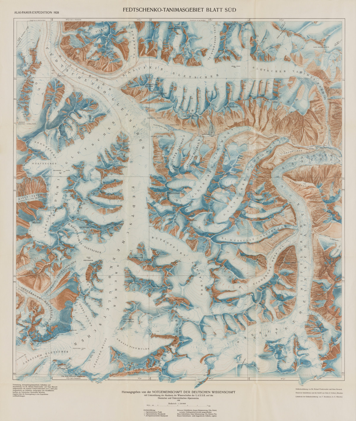
This was the German–Soviet Alai-Pamir Expedition, organized by the Soviet Academy of Sciences and the Emergency Association of German Science. Its task was to conduct a comprehensive study of the Western Pamirs, one of the most-unmapped and least-governed regions of the Soviet Union. In pursuing this goal, the team anticipated encountering ice, but they were struck by the sheer scale of what proved to be one of the world’s longest alpine glaciers, the Fedchenko—renamed Vanch-Yakh in 2023 by the Tajik government as part of ongoing post-independence efforts to rebrand the national territory. Among the expedition’s many achievements, the most enduring was the translation of this 77km giant into a topographic map, which remains a landmark in glacial cartography (Brun et al. 2025). By converting vast fields of ice and rock into precise coordinates, the map operated not only as an instrument of cryospheric construction but also as foundational infrastructural work, enabling future observation, movement and governance in the Pamirs. Ultimately, beneath the rhetoric of scientific knowledge for its own sake, this expedition emerges as a profoundly infrastructural endeavor, establishing new lines of movement, communication and knowledge across a region that had long resisted both comprehension and integration (Gorbunov and Scherbakov 1928: 19–20).
In 1928, the Western Pamirs lay within the Tajik Autonomous Soviet Socialist Republic (SSR), still administratively subordinate to the Uzbek SSR. Despite decades of imperial-era expeditions to this crossroads of empire, the high-mountain interior of the Western Pamirs remained, well into the 1920s, a classic ‘blank on the map’. The Russian Revolution and the creation of the Tajik SSR in 1929 reconfigured the region’s political status and intensified Soviet efforts to know, survey and administer the mountainous margins of the state (Bergne 2007). The call for what the expedition considered a scientific conquest of the Pamirs captured this colonial dual imperative: to render the territory legible while integrating it into socialist development. It was within this political and epistemic framework that the German–Soviet Alai-Pamir Expedition of 1928 took shape.
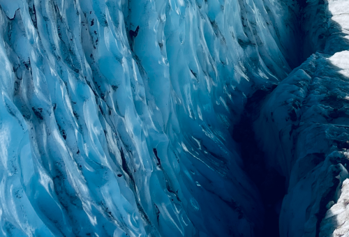
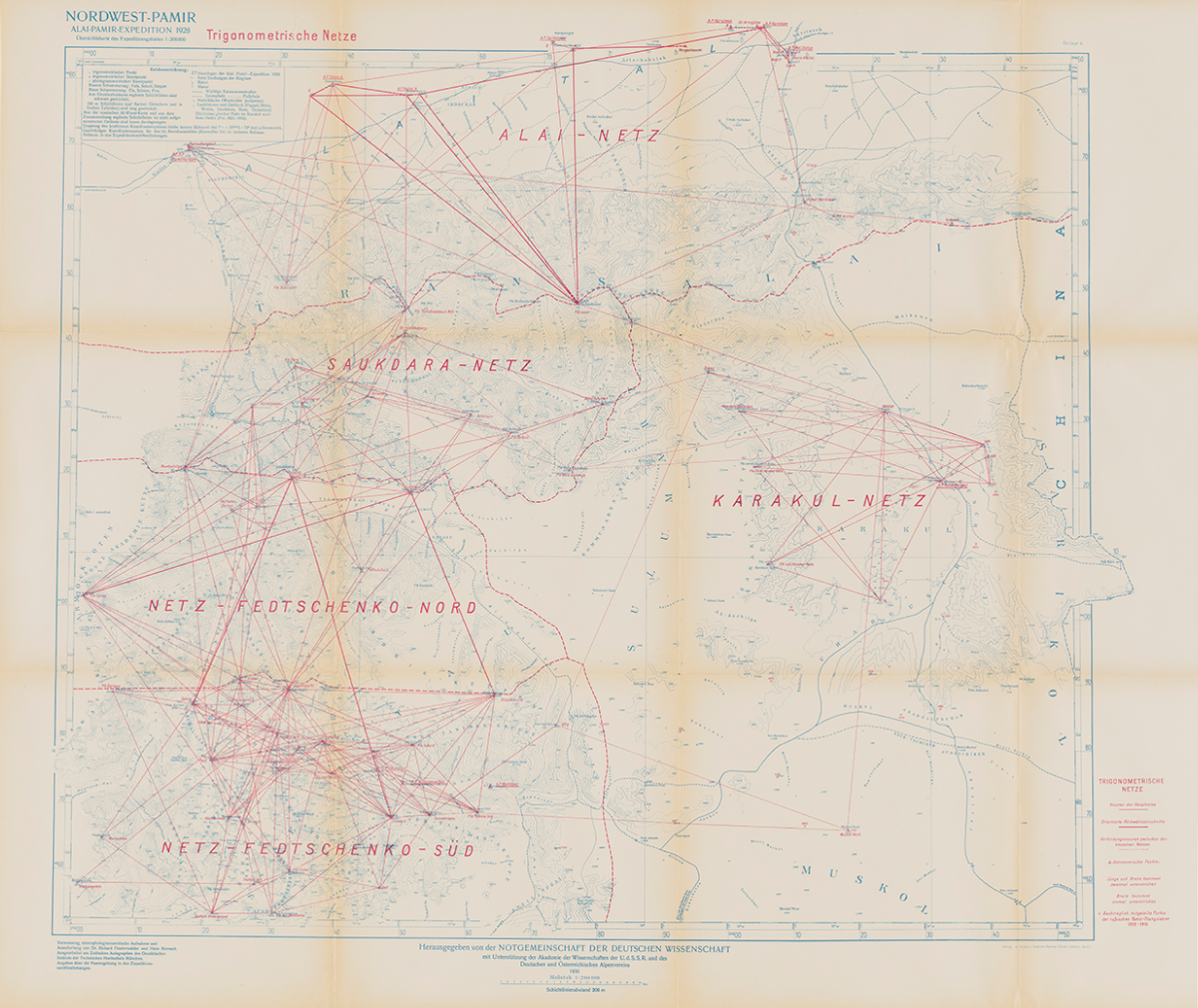
The expedition was as much a logistical undertaking as a scientific one. Traversing the Pamirs demanded an entire infrastructure of mobility—animals, porters, supply chains and communication lines. To “see like a state,” to borrow James C. Scott’s (1998) helpful metaphor, one had actively to construct the very means of vision: building the instruments, tracing the routes and establishing the practices through which knowledge could circulate. Nowhere was this need more evident than in relation to the Fedchenko Glacier. Long known by name but little more, the glacier fell largely outside both scientific knowledge and everyday awareness. Its remoteness and inaccessibility meant that even local populations attached no particular significance to it. Although it was a vital water source, its precise location, length and hydrological profile remained uncertain—an illuminated lacuna on official maps. The 1928 expedition set out to give form to that absence.
The Germans brought photogrammetric theodolites and a new system of high-altitude surveying, first developed by the German scientist and mountaineer Sebastian Finsterwalder in the Alps and applied in the Pamirs by his son, Richard Finsterwalder. The Soviets provided institutional authority and logistical coordination. Together, they established base camps and observation towers from where the surveyors could capture the all-important sightlines on which the rendering of the map depended. Ultimately the product of both arduous physical climbing and intricate mathematical calculation, the map thus represented a sophisticated fusion of mountaineering and technology as it translated a shifting, unpredictable glacier into legible form. Building on this foundation, by photographing and mapping the glacier onto a carefully laid out geometric grid, the scientists transformed it into a node within an expanding network of scientific observation and state oversight. At the same time, cameras, glass plates and measuring instruments extended human vision across the vertical and horizontal extremes of the Pamirs, collectively producing an apparatus that fundamentally reshaped how scale itself could be apprehended (von Ficker and Rickmers 1932). From the ground, the glacier appeared enormous and unstable, fractured by crevasses and obscured by rocky debris. Seen through the elevated perspective of photogrammetric imagery, however, it resolved into a smooth, continuous and intelligible surface—one that could be measured, monitored and ultimately managed (Gorbunov and Rastsvetaev 1934).
Through this process, the glacier became an infrastructural object. Measurements taken on the ice traveled by pack animal and train to Dushanbe, Tashkent, Moscow and Munich, where they entered circuits of calculation, analysis and publication (Rickmers et al. 1929; Rickmers 1930; Borchers 1931). Furthermore, the map that emerged from the expedition functioned as a blueprint for intervention, allowing planners to imagine—and impose—a new spatial order on what had previously been an opaque and little-known frozen landscape. Once rendered into a stable measurable object, the glacier could be connected to other infrastructures: irrigation systems, hydroelectric plants and transportation routes. As one Soviet observer noted, the glaciers of the Pamirs “contain in themselves the electrical energy of Dneprostroi and will satisfy the thirst of fruit gardens and cotton fields” (Romm 1936: 429). Through mapping, the glacier was repositioned within a chain of socialist development: glacier → river → canal → cotton field. In this way, the cryosphere became a point of departure for both hydrological planning and economic exploitation.
Within a few years, dozens of scientific detachments crisscrossed the Pamirs, covering the region with what one account described as “a net of routes”—human and animal paths linking deserts, valleys, peaks and glaciers into a single system of exploration and development (Romm 1936: 429). The 1928 expedition therefore served as a harbinger, the infrastructural spark that animated the Soviet state’s spatial imagination in Central Asia (Gorbunov and Rastsvetaev 1934: 15). The work extended beyond mapping alone, laying the epistemic and material foundations for a future in which the region’s glaciers would be harnessed as reservoirs of productive energy—a transformation of ice into economic resource.
But even as the map sought to establish infrastructure, the glacier constantly unsettled it. Survey poles sank into snow, markers disappeared overnight, instruments froze, tumbled or were buried by avalanches, all a relentless reminder of the glacier’s power. Its flows, ruptures and seasonal shifts resisted fixed cartography, revealing the limits of the infrastructural imagination and the impossibility of stabilizing the cryosphere within the rigid coordinates of a map. The instability persisted even after the Soviets had built a permanent observatory at 4,300 meters on the Fedchenko in 1933 and installed a portable meteorological station at 6,850 meters on what was then Stalin Peak and is now Ismoil Somoni—the ultimate statements of conquest (Gorbunov and Rastsvetaev 1934). Construction workers and researchers suffered frostbite, snow blindness and, in some cases, death, as the glacier’s hazards continued to defy human control.
The infrastructure of observation—designed to discipline and measure the ice—was thus continually undone by the forceful materiality of the subject. The glacier refused to stay still long enough to be fully known. Nor was this tension between infrastructure and ice simply metaphorical; it exposed the instability within the very concept of infrastructural control of ice. The glacier was both the foundation and the undoing of the systems built upon it. Its melting and movement were reminders that infrastructures, no matter how robust, are always made on shifting ground (Bennett 2019).

The 1928 map of the Fedchenko Glacier was more than a scientific accomplishment—it was an infrastructural act. Mapping the glacier meant building the logistical, optical and institutional systems that bound it to the Soviet state. The expedition caravan, its instruments, the labor it required, the data it produced and the later observatories that it maintained all constituted an infrastructure through which the cryosphere became measurable and, in theory, governable. But the glacier itself, with its perpetual viscous motion, which the scientists closely observed and measured (Fersman et al. 1933), was a disruptive agent that resisted the imposition of infrastructure and reminded Soviet planners that socialist modernity had its limits and could not fully subordinate nature to ideological ambition. The Fedchenko could be mapped and measured, yet it could not be fully stabilized within human systems of understanding. Its very materiality—melting, shifting, flowing—was a form of counter-infrastructure, one that continually reasserted and still reasserts the autonomy of the cryosphere. The 1928 expedition thus marked the beginning of a new relationship between science, infrastructure and the frozen world: here maps rendered glaciers intelligible, infrastructure gave maps material form, and the glacier, in turn, unsettled both.
Ask students to look at the map and imagine everything had to happen for this image to exist—the people, animals, instruments and necessary food supplies moving across the Pamirs. Have them jot down what the map makes visible and what it smooths over or hides.
Bergne, Paul. 2007. The Birth of Tajikistan: National Identity and the Origins of the Republic. I.B.Tauris.
Bennett, Mia M. 2019. "Midnight Blues in the Melting Arctic." Roadsides 1: 43–50.
Borchers, Philipp. 1931. Berge und Gletscher im Pamir. Verlag von Strecker und Schröder.
Brun, Fanny, Astrid Lambrecht, Christoph Mayer, Janali Rezaei, Amaury Dehecq, Luc Béraud, César Deschamps-Berger, Etienne Berthier, Christof Völksen and Abdulhamid Kayumov. 2025. “Multi-Temporal Elevation Changes of Fedchenko Glacier, Tajikistan, from 1928 to 2021.” Journal of Glaciology 71: 1–44.
Fersman, Aleksandr, Nikolai Gorbunov and Viktor Vasil’ev (eds.). 1933. Таджикская комплексная экспедиция 1932 года. Goskhimtekhizdat.
Gorbunov, Nikolai and Mikhail Rastsvetaev. 1934. Работа АН СССР в Таджикской ССР// Академия Наук СССР республикам Средней Азии. 1924–1934 г. Izd. SOPSA.
Gorbunov, Nikolai and Dmitrii Scherbakov. 1928. “Памирская высокогорная Советско-Германская экспедиция 1928 года.” In Труды Памирской экспедиции, edited by Nikolai Gorbunov and Dmitrii Scherbakov, 1–23. AN SSSR.
Rickmers, Willi Rickmer. 1930. Alai!Alai! Arbeiten und Erlebnisse der Deutsch-Russischen Alai-Pamir Expedition. F.U. Brodhaus.
Rickmers, Willi Rickmer, Richard Finsterwalder, Ludwig Nöth, William Reinig, Wolfgang Lentz, Philip Borchers and Karl Wien. 1929. Die Alai-Pamir Expedition 1928, Deutsche Forschung Aus der Arbeit der Notgemeinschaft der Deutschen Wissenshaft. Siegismund.
Romm, Mikhail. 1936. The Ascent of Mount Stalin. Lawrence and Wishar.
Scott, James C. 1998. Seeing like a State: How Certain Schemes to Improve the Human Condition Have Failed. Yale University Press.
Schneiderov, Vladimir. 1929. На высотах мира. Дневник кино-экспедиции. Teakinopechat’.
von Ficker, Heinrich and Willi Rickmer Rickmers. 1932. Wissenschaftliche Ergebnisse der Alai-Pamir Expedition 1928. D. Reimer and E. Vohsen.